 Togo Travel Guide - Voodoo, Beaches & UNESCO Culture

.
Travel Notes: Africa - Togo Travel Notes.


Short URL: https://tnot.es/TG
Togo Travel and Tourism on Travel Notes
Travel to Togo - West Africa's Hidden Gem Awaits Your Discovery
Togo, with its friendly people, captivating landscapes, and rich culture, is an off-the-beaten-path destination that will leave you with memories to last a lifetime.
About Togo
During the 18th and 19th centuries, the area of Togo had the Ashanti Kingdom to the west (Ghana), and the Kingdom of Dahomey to the east (Benin).
Forget the crowded tourist spots – Togo, a slender sliver of a nation nestled between Ghana and Benin in West Africa, offers an authentic and unforgettable adventure.
With beautiful beaches, vibrant markets, and stunning landscapes, Togo offers visitors a unique blend of traditional African culture and modern amenities.
Countries neighbouring Togo: Ghana, Burkina Faso and Benin.

 Add a Business Listing -
Add a Location -
Add a Lodging - Add Travel Content
- Add URL
- Travel Services.
Add a Business Listing -
Add a Location -
Add a Lodging - Add Travel Content
- Add URL
- Travel Services.
Mapping Togo
Map of Togo
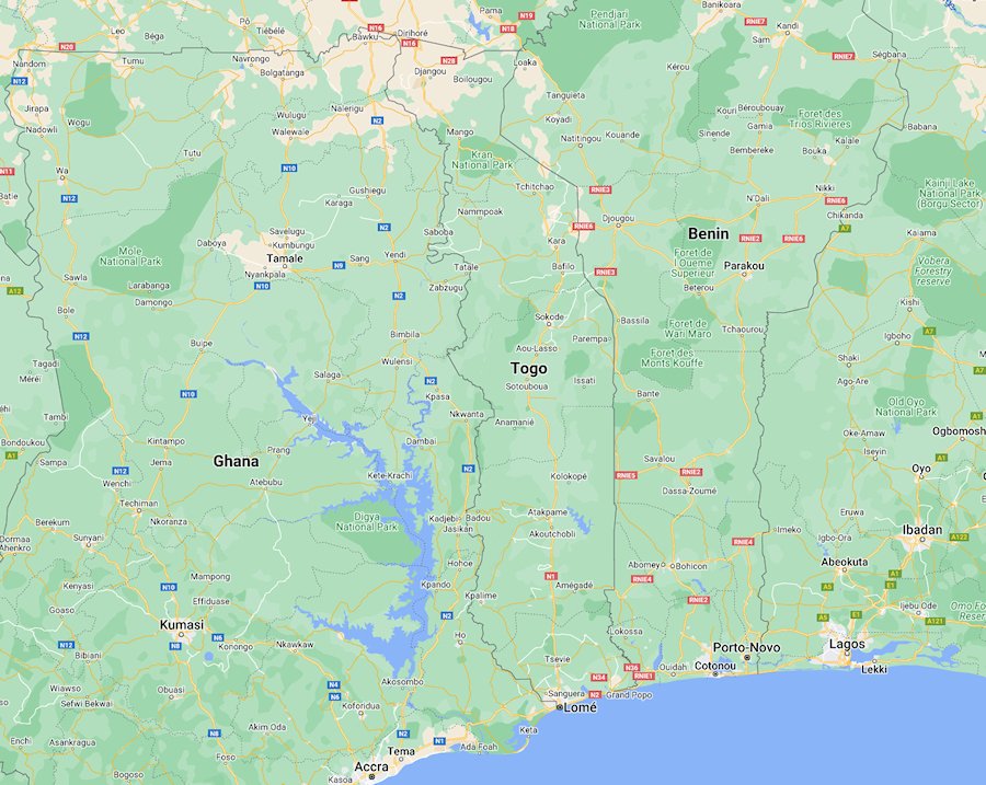
Togo has a diverse landscape that includes stretches of coastline along the Gulf of Guinea, rolling hills, and savannas.
Lomé, the capital of Togo, is situated along the Gulf of Guinea; on the road between Cotonou and Accra.
Togo Overview
Togo is a country located in West Africa, bordered by Ghana to the west, Benin to the east, and Burkina Faso to the north.
Togo is a country with a rich cultural heritage, diverse population, and potential for economic growth, despite the challenges it faces.
Challenges
Like many countries in the region, Togo faces challenges such as poverty, inadequate infrastructure, and political instability.
However, there have been efforts to address these issues and promote sustainable development.
Culture
Togolese culture is rich and diverse, with influences from indigenous traditions, colonial heritage, and neighbouring African cultures.
Traditional music, dance, and festivals play an important role in Togolese society.
Economy
Togo's economy is primarily agricultural, with the majority of the population engaged in subsistence farming.
The main crops include cotton, cocoa, coffee, and yams.
Togo also has mineral resources such as phosphate, which is a major export.
Language
French is the official language of Togo, inherited from colonial times.
However, various indigenous languages such as Ewe and Kabiyé are also widely spoken.
Politics
Togo gained independence from France in 1960.
Since then, it has experienced periods of political instability and authoritarian rule.
However, in recent years, there have been efforts towards democratisation and political reform.
Population
The population of Togo is diverse, consisting of around forty different ethnic groups.
The largest ethnic groups are the Ewe in the south and the Kabye in the north.
Tourism - Unique Cultural Experiences in Togo
Togo has several attractions for tourists, including its beautiful coastline, national parks such as Fazao-Malfakassa National Park, and cultural sites like the Akodessawa Fetish Market in Lomé.
Celebrate With the Locals
Togo bursts with festivals throughout the year.
Immerse yourself in the joyous drumming and vibrant costumes of the Evala, a harvest festival held in the northern part of the country, or witness the colourful parades and masquerades of the Anié dance festival.
Explore the Koutammakou UNESCO World Heritage Site
Wander through the 'Takienta', traditional mudbrick houses with distinctive round roofs, in the villages of the Tamberma people.
Witness their unique way of life and appreciate the architectural ingenuity that earned their homes a place on the prestigious UNESCO list.
Immerse yourself in Voodoo
Beyond the Hollywood stereotypes, Voodoo is a complex spiritual tradition deeply woven into Togolese life.
Visit the Akodessawa Fetish Market in Lomé, the capital city, and witness a vibrant display of traditional artifacts and charms.
Remember, respect is key when approaching this cultural landmark.
Visiting Togo
French is the official language of Togo, so having some basic French phrases can be helpful for communication; especially outside major tourist areas.
Accommodation
Togo offers a range of accommodation options, including hotels, guesthouses, and lodges.
In urban areas like Lomé, you'll find a variety of hotels catering to different budgets.
It's advisable to book your accommodation in advance, especially during peak tourist seasons.
Currency
The official currency of Togo is the West African CFA franc.
It's advisable to exchange currency at banks or authorised exchange offices.
Credit cards may be accepted in larger establishments in urban areas, but it's always good to have cash on hand, especially in rural areas.
Food and Drink
Togolese cuisine is diverse and flavourful, often featuring dishes made with staples like maize, rice, yams, and plantains, accompanied by sauces and stews.
Don't miss trying local specialties such as fufu (a dough-like dish made from cassava or plantains) with sauce, grilled fish, or akoumé (cornmeal pudding).
Be sure to also try Togolese beverages like palm wine or sorrel juice.
Health Precautions
Check with your healthcare provider regarding vaccinations and medications recommended for travel to Togo, such as yellow fever vaccination.
It's also advisable to take precautions against malaria and other tropical diseases.
Respect Local Customs
Togolese people are generally friendly and hospitable, but it's important to respect local customs and traditions.
Dress modestly, especially when visiting religious sites, and always ask for permission before taking photos of people.
Safety
While Togo is relatively safe for tourists, it's essential to take common-sense precautions such as avoiding displaying valuables openly and staying alert in crowded areas.
Sightseeing
Explore the attractions Togo has to offer, such as the vibrant markets of Lomé, the scenic beaches along the Gulf of Guinea, and the cultural sites like the Akodessawa Fetish Market or the Tamberma Valley with its unique Togolese mud tower houses.
Top Tourist Attractions
Explore Lomé
Visit the bustling Grand Marché, the largest market in West Africa, or delve into history at the National Museum of Togo.
Hit the beach
Relax on the palm-fringed shores of Lomé, or venture further for quieter stretches like Aného with its historic slave port.
Trek through the stunning landscapes
Hike the Atakora Mountains in the north, offering breathtaking views and diverse wildlife, or kayak through the mangroves in the Togolese coastal lagoon.
Transportation
While in Togo, you can use various modes of transportation such as taxis, buses, and rental cars to get around.
In cities like Lomé, taxis and motorcycle taxis (known as 'zemidjans') are readily available.
However, be prepared for traffic congestion, especially during peak hours.
Travel Documents
Ensure you have a valid passport and any necessary visas for entry into Togo, depending on your nationality.
Lomé
Map of Lomé
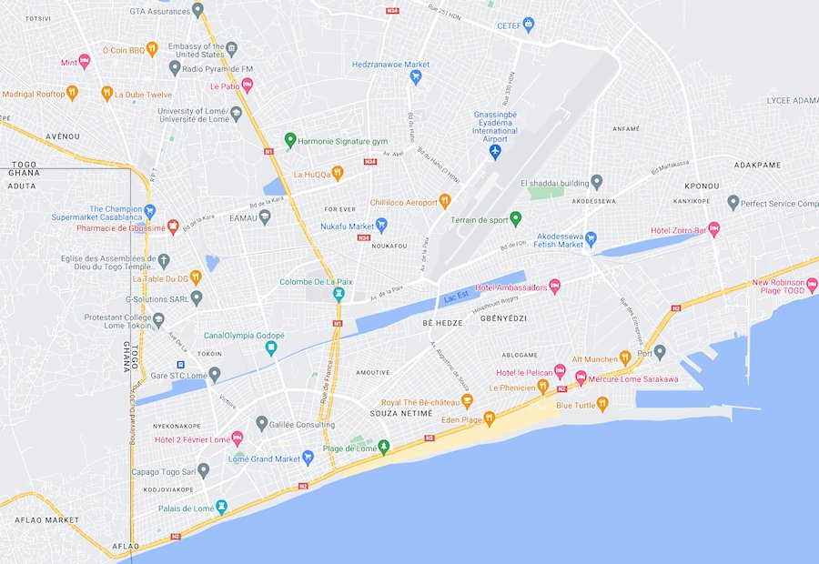
The capital of Togo is situated on the Gulf of Guinea, near the border with Ghana.
Lomé grew after 1897 as the capital of German Togoland.
A period of Anglo-French control (1914-1922) and to French control (1922-1960), before becoming the capital of independent Togo in 1960. Population (1985 estimate) 400,000.
Napoleon Lagune

Napoleon Lagune: 01 Rue 20, Lomé, Togo.
The hotel has cosy rooms and a year-round outdoor pool and views of the lake.
Guests who stayed at the Hotel Napoleon Lagune liked the stunning views, comfortable beds and level of service provided by staff.
Where to Stay in Togo
Togo offers a variety of accommodation options to suit every budget and travel style.
Eco-lodges
Immerse yourself in nature and support sustainable practices by choosing an eco-lodge, often located near national parks or beaches.
Homestays
Experience true Togolese hospitality by staying with a local family, gaining insights into daily life and practicing your French.
Luxurious Hotels
Lomé boasts several international chains for those seeking comfort and familiar amenities.
Travel Around Togo
Togo varies in width, from 40 to 130km, as it extends about 550km up from the Gulf of Guinea, between Benin and Ghana.
Togo by Road
The coastal road runs through Lome between Benin and Ghana, while another road goes north to Burkina Faso.
Togoland
The German protectorate of Togoland was established in 1884.
During the first month of World War I (August 1914), French and British forces invaded the region and forced the Germans to surrender the territory.
In 1920 Lome and the entire coastline, comprising the eastern two-thirds of the pre-1914 German colony, were assigned to France as French Togo.
The smaller, western section was administered by Britain as part of the Gold Coast.
French Togoland achieved independence on April 27, 1960, as Togo.
Language of Togo
The official language of Togo is French, while Ewe and Kabre are the main African languages used.
Republique Togolaise:
News and articles about Togo; in French.
Togo Maps and Travel Guides

Togo Travel Guides - Togo Maps.
Weather in Africa:
Local weather forecasts for destinations around Africa.


|
|
More From Travel Notes
Travel Notes Online Guide to Travel
Africa - Asia - Caribbean - Europe - Middle East - North America - Oceania - South America.

The Travel Notes Online Guide to Travel helps visitors plan their trip with country and city travel guides, local tourist information, reviewed web sites, and inspiring travel content.
Travel Collaborations
Where travel creators, brands, and tourism partners connect and collaborate on real campaigns.

Travel Collaborations is a TravelNotes.org inspired B2B Network connecting content creators and digital nomads with travel destinations, hotels, and tourism brands looking for authentic storytelling on real campaigns.
Travel Resources
![]()
.
Travel & Tourism With Industry Professionals.
 Travel Writer, Photographer and Internet Publisher")
During 40 years of travel & living abroad Michel has visited some 120 countries, 220 UNESCO Heritage Sites and 100+ World Heritage Cities.
